- Seasonal flow patterns and disruptions
- Drinking water wells
- Organic gardening
- No planned testing of well water and irrigation water
- Risk of well water contamination
- Public perception issues
If this was done, eradicating elodea should be part of the equation, even if it means using herbicide. As it stands, there are NO plans to improve the flow of the Chena Slough, but many state and federal agencies have shown an understanding and desire to do so.
 |
| Chena River King Salmon |
Here are some ideas that might help to mitigate these weaknesses or shortfalls. This plan will certainly need some tweaking, but nobody knows the Chena Slough better than I do...except maybe that kid in the red canoe who paddles by my house every night at 7:30. If anyone needs clarification on any of these points, please ask.
The Ongoing Plan
The DNR's plan (presently under permitting consideration) involves using two formulations of Sonar (fluridone) in a sweeping effort to treat ~8 miles of Chena Slough. According to the (rough) calculations, this stretch of slough is 120' wide and 3' deep, comprising 118 surface acres (SA). The slough is a flowing body of water, average 52 cubic feet per second (CFS). At these dimensions, there are 354 acre feet (AF) of water and at an average flow rate of 52 cfs, a daily exchange of 103AF/day.
Chena Slough is located in the middle of Alaska, what we call "The Interior."

In this plan, 2,495 pounds of pelleted formulation of fluridone (Sonar H4C) will be spread evenly over the entire slough in two doses (Spring and Fall). Also, a drip applicator device would be installed on private property to apply a liquid formulation (Sonar Genesis) at a predetermined rate throughout the open-water season (May-September). The slough was divided into 5 management zones, per the original plan, thus:

The idea behind this method is to lay a groundwork of slowly dissolving pellets and augment their eventual demise with a steady-state liquid. The plan calls for four years of similar treatment, with successively lower doses in subsequent years as the elodea disappears.
For fluridone to be effective, it must stay in contact with the underwater plants for 45-90 days. This plan calls for maximum contact for 3-4 years. Essentially hoping to eventually kill everything. A mop-up phase at the end is the "exit strategy."
I see some flaws with this plan.
A. It treats the entire slough at the same time. If the treatment is a failure, ie. kills untargeted plants, fish, or gets into drinking wells, it will be a large area and the liability large. There is no "experimental" phase, this is all-or-nothing, or as they say in the industry, "spray and pray."
Final control costs can vary greatly depending on the region in the state, cost of the herbicides and equipment, personal preferences of methods used, soil and field conditions, weed spectrum, availability of labor and equipment, market price, and a host of others. In other words, there are no silver bullets. Whether you like to use “spray and pray”, mechanical, or a combination of the two techniques, select the program that best suits your weed control and budget concerns.B. It does not take into account flow variances throughout the treatment site. On-the-ground technicians will need to walk the entire slough daily to remove beaver dams or fallen trees. The application rate of the drip herbicide for the entire slough will be dependent on isolated low or high flow sections. The flow rate in the slough was calculated at 54cfs, but in reality it increases from 20cfs at Plack rd to 100cfs at the mouth of the slough. Additionally, the calculated depth of 3 feet is very misleading. Miles-long stretches of the slough are 3 inches deep, with 3 feet of muck underneath. Isolated pockets are up to 15 feet deep. Anyone who has attempted to canoe in the Chena Slough will laugh at the mention of "3 feet deep."
C. Water wells. There are 50-100 water wells "close by" the slough. Many are within 50 feet, lots more 50-200 feet. And many, many more (hundreds to thousands) within 1/2 mile. The residents in this area are leery because there is a large plume of underground water in North Pole that is contaminated by an industrial solvent (sulfolane) that was accidentally released by a local oil refinery (hey, it's Alaska!). This contaminated water is moving in the direction of the elodea treatment area. People here are very aware that the groundwater is not immune from unwanted chemicals. The plan calls for no testing of local water wells because the EPA allows 150ppb of fluridone in drinking water, and there is little chance of exceeding that amount. This line of thinking does not sit well with residents who watch local neighborhoods decline in value as their water is identified to be contaminated.
D. Gardening. The Sonar labels say you cannot use treated water (over 5ppb) to irrigate vegetables, especially tomatoes. The water must be tested prior to irrigation. The plan does not call for identification of people who use an irrigation system, nor does it allow for spot testing of water, or soils on which treated water was used. Sonar (fluridone) is very persistent in soil, and can damage crops planted in soil that was watered from treated water the season prior.
E. Public perception. The proposed plan does not allow for change once it begins. If fluridone appears in water wells, or trees start to die, we just have to wait and see what happens, There's no going back. It would be like dumping a bag of tennis balls down a flight of stairs. There's no stopping it now! People get no chance for "buy in." If someone is adamantly opposed, all the State can do is send in "jack-booted thugs" to set things straight. Sabotage of equipment or hostile confrontations are a possibility. Emotions run high in this atmosphere.
My Proposed Plan
Apply fluridone at the recommended rates in a phased approach, delineated by bridges:
- Begin the treatments at the mouth of the slough, and treat only a portion of the slough in the first year.
- Sample all of the 10-12 water wells in this area using an independent test lab, such as Pacific Ag Labs in Portland [contact: Steve Thun; ~$150 per test].
- Sample water in the areas used for irrigation.
- Sample sediments.
- Inventory all wells in the area for depth, age, contaminates.
- Provide community outreach for alternative water source, i.e. collected rain water, well water, for organic gardening.
- Inventory plants, insects, fish, and animals effected by the treatment.
- Monitor fluridone concentrations in the treatment area by SePRO FasTEST and random third party testing.
- Consult with SePRO specialists to determine formulations and amounts as allowed by EPA.
Year 1 -

Goals for Year 1:
- 100% landowner approval
- Organic gardeners happy
- Zero ppm fluridone in wells
- 4-8ppm fluridone in water
- Gathering important baselines for herbicides in wells, soil, and sediment
- Determining efficacy and effectiveness of treatments
Comments about this section:
- 100% of motorboat traffic is limited to this section of slough due to culverts at Persinger.
- All of this area accessible by boat from the boat launch at Nordale or Fairbanks. No access issues.
- "Ice-trapped elodea" in this area is discharged into the Chena each spring, ice above Persinger does not travel to the Chena, it melts in place (due to culverts).
- Persinger Bridge is a very popular fishing spot.
- This is the highest traffic section of the slough, easy access, deeper water, good fishing.
- People will be able to look at an untreated area and a treated area from Persinger bridge.
- Collateral damage relatively small in case of adverse events.
- Flow rates in the YELLOW area are very constant at ~50cfs.
- Approximately 1 mile long.
- This is where I live. I will keep a close eye on things!
Red Zone:
- This section is hard-bottom and fast flowing, very little elodea present. Fluridone will not be effective in this very fast water. ~100cfs as slough narrows from 120' to 20' wide.
- This section is subject to frequent flood events and follows the level of the Chena River.
- Part of this section was left off of the original plan, but is a part of the slough.
- This section is prime spawning area for Grayling, chum salmon, whitefish, and suckers.
YEAR 2 -
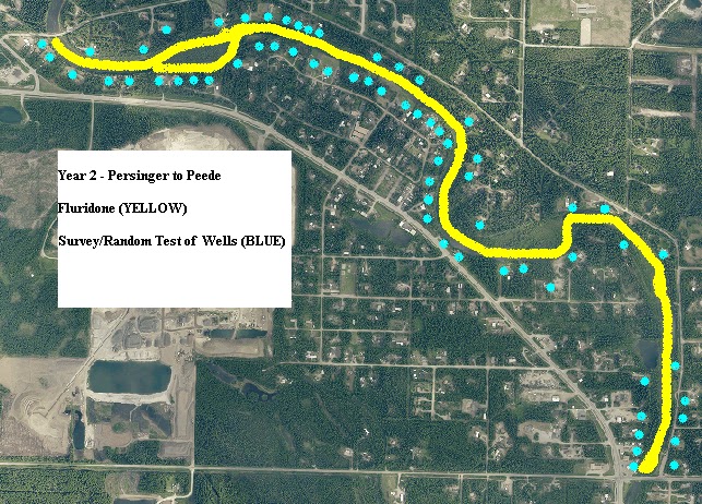
Goals for Year 2:
- 100% landowner contact and approval
- Organic gardeners happy
- Zero ppm fluridone in wells
- 4-8ppm fluridone in water
- Gathering important baselines for herbicides in wells, soil, and sediment
- Using lessons learned from year 1 for outreach.
Comments about this section:
- Very shallow, very weedy. Hard to navigate by boat of any type. Good access at Badger Gas.
- Peede Rd bridge/park (behind Badger gas) is the most popular fishing spot in North Pole.
- No motor boat traffic.
- Peede Rd bridge is popular put-in spot for canoes and kayaks.
- Traditional grayling spawning ground. At one time, this area produced 30-50% of Chena's Grayling.
- Lots of moose.
- Lots of beaver activity.
- Only the lower 1/3 is effected by Chena River flooding.
- Approx 40cfs flow, lots of stagnant areas.
- Approx 3 miles long.

Goals for Year 3:
- 100% landowner contact and approval.
- Organic gardeners happy.
- Zero ppm fluridone in wells.
- 4-8ppm fluridone in water via pellets or liquid.
- Gathering important baselines for herbicides in wells, soil, and sediment.
- Using lessons learned from years 1 and 2 for outreach.
- Before starting year 3 treatments, assess effects of years 1 and 2. If ineffective, consider stopping the program and trying something else.
Comments about this section:
- Very shallow, very weedy. Thick muck layer. Hard to navigate, even by foot.
- Almost no canoe or kayak activity.
- Almost no fishing.
- No motor boat traffic.
- Lots of stagnant water. Flows from 20-30cfs.
- Lots of moose.
- Lots of beaver activity.
- Gravel pit to test for fluridone.
- Approx 4 miles long.
- Repeat year 3 protocol to clear out this last presence of elodea if required.
- Examine whole treatment area for pockets of elodea.
- Continue to test wells, water, sediment by request or random sampling.
Random Thoughts
I know this plan will require lots of work, but it should prove easier than the original plan. This plan has an additional benefit, that if funding is stopped before year 4, there will have been successful eradication in the most sensitive areas, and perhaps other methods can be used to control the remaining elodea, such as elodea barriers at the culverts. Under the current plan, if funding is lost after year 1 or 2, the entire project is a failure.
Exact distances, depths, and flow rates need to be determined for each treatment area. But they will be found to be very uniform in the areas I segregated.
If no local talent is available, a SePRO specialist will be happy to assist, I'm sure.
Landowner buy-in will be phenomenal if each year produces visible results as witnessed from the key bridges delineating the treatment zones.
Periodic public meetings with updates will be fun if this all goes well. If it goes badly, we can simply stop and regroup.
If this proves an environmental disaster, it can be halted in "year 1" with lessened liability.
The tolerance for fluridone found in water wells needs to be ZERO. If even 1ppb is found in a drinking well, we must halt the entire plan until the extent and route of the ground water incursion is investigated.
There is a good possibility that sulfolane from the refinery will enter the slough in 2016 or 2017. Organic gardeners will appreciate the outreach to learn new methods of watering gardens.
When the treatment moves to a new zone each year, the previous zone will still receive fluridone from upstream as the new treatment year begins. At the end of year 4, zone 1 will have had 4 years of continual low-level treatment.
Using a third party test lab will eliminate the appearance of a conflict of interest as opposed to using the Sonar distributor's testing services.
If this proves a success, we can all say we did our part, just as John Morton from the Kenai NWR did.
Please leave any comments or concerns. I'm sure I forgot something. You can comment anonymously if you like, or email me at akman2014@live.com
ANYONE, feel free to use, borrow, plagiarize, or steal ANY of this info without the need to cite or credit me or this blog. This is a public service and is now part of the public domain.
Happy Hunting!
Tim Steele
 | |
| View from my bedroom |
Tim - I have been biting my tongue since last year waiting to see what will happen. I work for a company that sells pesticides and I have seen some extremely shocking sales techniques that downplay dangers of the chemicals. If a pesticide is a RUP (Registered Use Pesticide) it has specific application protocols that must be followed. The sales rep can tell you anything you want to hear to make a sale, but has no liability if something should go wrong (read the fine print).
ReplyDeleteIt must be sad watching your slough disappear and Alaska turn into a chemical dump like the rest of America.
Alaska is dotted with superfund cleanup sites. Most were caused by the military or mining/refining industry. People come to Alaska with chemicals, dump them where they please, and go back home to Indiana or where ever they are from.
DeleteA company spokesman has one goal in mind: selling products. Why not? That's their job, some are good at it. But when you get into a situation like this, there is no one around to check that what the salesman says is accurate. You have to rely on them to do what is best. Usually what is "best" is what you can "afford." Funny how that works, eh?
I will tell you with great certainty that sulfolane will not get into the groundwater if the Chena Slough has a mucky bottom. It binds to the dirt in that case. Unless there are some strange hydraulic forces going on, you are safe.
ReplyDeleteAny updates?
ReplyDelete